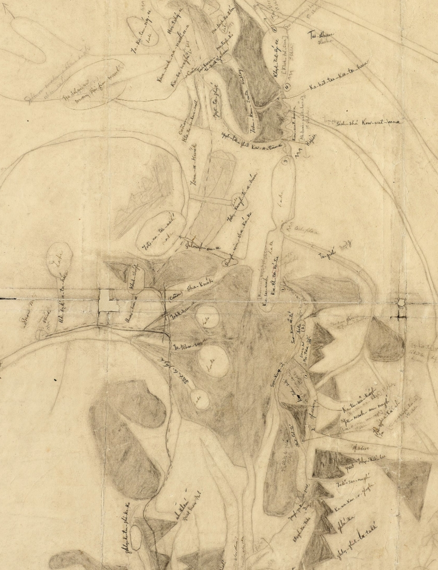
Detail of the “large Kohklux map,” drawn in 1869 by Chilkat headman Kaalaxch’ (Kohklux) and his wives, with notes by U.S. government surveyor George Davidson. G4370 1852.K6, MAP COLLECTION, THE BANCROFT LIBRARY, UNIVERSITY OF CALIFORNIA, BERKELEY
Detail of the “large Kohklux map,” drawn in 1869 by Chilkat headman Kaalaxch’ (Kohklux) and his wives, with notes by U.S. government surveyor George Davidson. G4370 1852.K6, MAP COLLECTION, THE BANCROFT LIBRARY, UNIVERSITY OF CALIFORNIA, BERKELEY
by Corinna Cook
Summer 2022, FORUM Magazine
DEEP IN SOUTHEAST Alaska’s Chilkat Valley, three people bend over the blank back of a coastal chart—discussing, drawing, shading, remembering. They are Chilkat headman Kaalaxch’ (Kohklux) and his two wives. For three days, they pool their memories, experiences, and knowledge of the land that stretches over six hundred kilometers from Klukwan to Fort Selkirk. They are mapping the way inland for a newcomer, U.S. government surveyor George Davidson. Davidson and his party are here to observe a solar eclipse calculated to reach totality at Klukwan, and Kaalaxch’ has guided them here into his homeland. Now, he and his wives draw each day of the month-long journey. They do so from memory. It is August 1869.
To the south, the Takinsha Mountains and Chilkat Range rise from sea to sky. Below them lies Lynn Canal, a tempestuous but rich Pacific fjord. Up the valley, the trio draw pencils across the page and alongside them flow the frigid, milky waters of the Chilkat River. Hooligan, or candlefish, seasonally swell its current. To the north, the sheer rock faces and year-round snowfields of the Takshanuk Mountains stand hard against the sky.
Looking back from the present day, former territorial archivist Linda Johnson imagines arriving as a newcomer into the Chilkat Tlingits’ homeland. “If you were George Davidson and others coming up the Chilkat [River Valley] for the first time, all you see is a wall of
mountains,” she reflects. “The route goes through that barrier in a very precise way.”
Across the page, Kaalaxch’ and his wives pencil everything from distinctive mountain profiles, riverways and lakes, and meeting places with inland people. Later, Davidson will listen attentively to his hosts and learn place names along the their hand-drawn map will stun local experts, GIS mappers, and geographers over a century later.
“We have thousands of mental pictures gathered into one place,” says Tom Buzzell, Champagne and Aishihik First Nations citizen and First Nations Liaison Officer for Kluane National Park and Reserve. “It’s a download of what was going on in their minds that day.”
The map Kaalaxch’ and his wives drew on the reverse of a coastal chart is now known as the “large Kohklux map.” There also exists a “small Kohklux map,” because Kaalaxch’ first sketched the route for Davidson on a notebook-sized sheet of paper, but needed more room to include sufficient detail. Today, the Koh- klux maps reside in the Bancroft Library archives, in Berkeley, California.
These extraordinary documents are the earliest known maps of southern Yukon. They are also the first known maps committed to paper by Indigenous people in the Alaska-Yukon region.
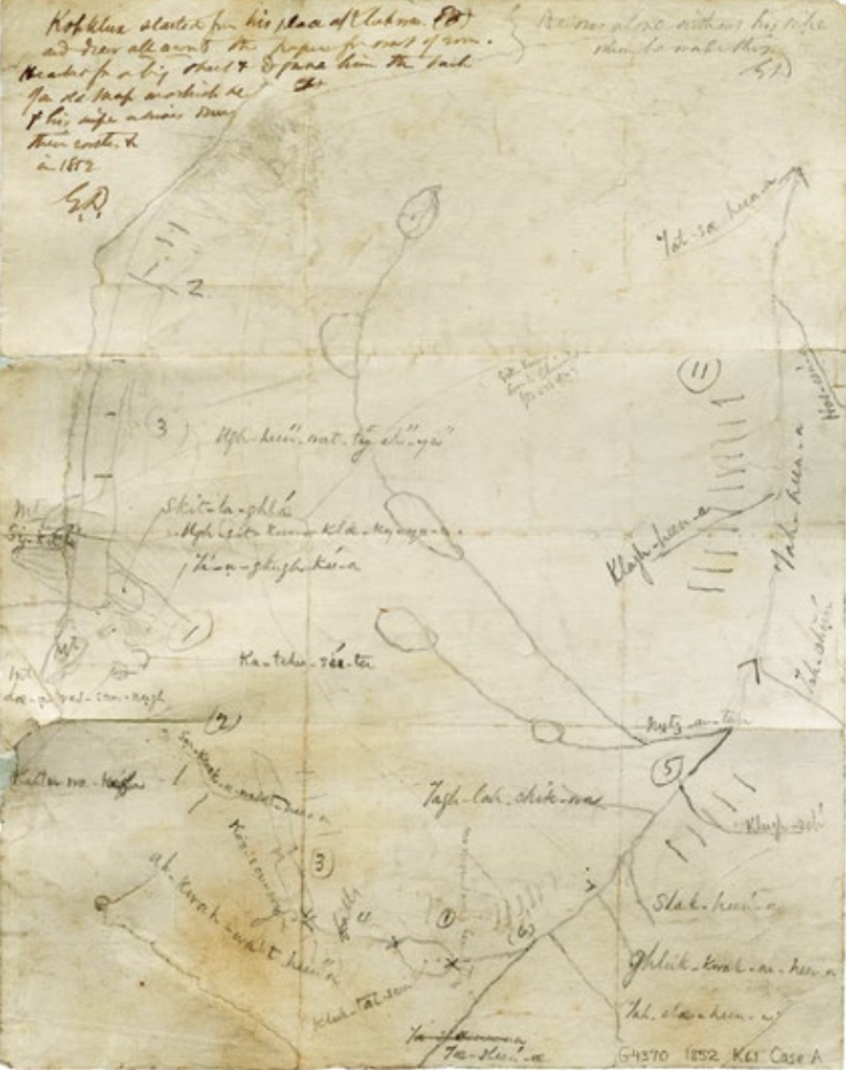
First rendered in Davidson’s notebook, the “small Kohklux map,” proved too confining to provide sufficient detail. G4370 1852.K61, MAP COLLECTION, THE BANCROFT LIBRARY, UNIVERSITY OF CALIFORNIA, BERKELEY
A MOST IMPRESSIVE ARCHIVE
A few autumns back, 150 years after the maps’ drawing, Alaska Natives, First Nations Yukon people, U.S. and Canadian scholars, technical professionals, and artists came together in Haines Junction for a potlatch, and they gathered again the following weekend for a conference in Whitehorse to commemorate the drawing of the maps, pondering the ongoing cross-cultural exchanges it represents. Most importantly, they came together to discover old connections and create new ones.
Aptly bearing the name “Our Trails Bring Us Together,” the conference included cultural performances, panels and talks, slideshows, storytelling, an art installation, and ample attention to audience dialogue. On the first day of the conference, Klukwan, Alaska, community members Lani Hotch, Jack Hotch, and Marsha Hotch performed in full re-
galia, filling Whitehorse’s Kwanlin Dün Cultural Centre with drumbeats, voice,and dance. Between songs, Lani Hotch, a Klukwan Elder, curator, and cultural education specialist at the Jilkaat Kwaan Heritage Center, set the tone of the gathering with this statement: “We’re all here together for a few days, and we need to prepare our hearts for what’s to come.”
Later in the conference, several First Nations leaders emphasized an important point about the maps’ purpose: “These maps weren’t for us,” said Steve Smith, Chief of the Champagne and Aishihik First Nations. “These maps are for those of you who would get lost.”
Champagne and Aishihik First Nations Elder Ron Chambers raised a similar point in his presentation: “They were people who knew how to find their way up here,” said Chambers. “They didn’t need a map. Their language was their map. Davidson came and he needed a map. They were able to make one for him.”
Reflecting on these sentiments after the conference, Johnson suggested we temper “our excitement and awe that we have for these maps with some of the reality that Tlingit ancestors had all that information in their heads and carried it around with them everywhere they went.” The physical maps are, of course, an extremely valuable resource for the Indigenous descendants of people who traded in the region, as well as for today’s historians, ethnographers, and linguists. Yet, as powerful as the documents are, Smith’s and Chamber’s point is essential. “That is the more impressive archive,” Johnson reiterated. “What people carried in their minds.”
TIES OF CULTURE, FAMILY, AND TRADE
Indigenous people in Alaska and Yukon have been active traders and long-distance travelers long before contact with Europeans. Coastal Tlingit people crossed the mountains into southwest Yukon carrying packs loaded with cedar, shells, and hooligan oil. The latter was such a central trade item that this coastal-inland route is often known as “the Grease Trail.” Hooligan oil was primarily eaten with other foods or used to preserve berries, herbs, roots, and salmon eggs. Southern and Northern Tutchone people met their Tlingit trading partners at well-known sites to exchange the inland biome’s superior-quality furs, hides, copper, ochre, gopher robes, and skin clothing for the coastal resources.
“Our ancestors were so fit,” says Lani Hotch. “Our ancestors walked everywhere.” The over 600 kilometer route Kaalaxch’ and his wives mapped from Klukwan to the confluence of the Yukon and Pelly rivers at Fort Selkirk represents a one-month journey—each way.
To conduct the trading, each side designated leaders according to their protocols. Often, women had the final say in exchanges. After business was done, people celebrated with feasting, songs, dances, stories, and gifts. Marriages between Tlingit and Southern and Northern Tutchone people strengthened trade partnerships by creating familial closeness. Inter-family relationships softened the borders between groups and averted conflict, for such social and intercultural practices positioned traders not only as business partners, but as kin. Family ties established long ago continue today.
“They didn't need a map. Their language was their map.”
SYMBOL OF PEACE, COOPERATION, AND EXCHANGE
In contrast with such enduring continuities, dramatic changes of settler-colonial contact also mark the region’s history. European and American explorers sailed into the region in the mid-1700s. By the 1800s, Russia had claimed Alaska and started exploiting its fur resources, a large-scale economic project which entailed a degree of business cooperation—and violent conflict—with coastal Tlingits.
Around the same time, British fur traders expanded through North America, ultimately tapping into the interior Yukon fur trade with the establishment of a Hudson’s Bay Company post at Fort Selkirk. This did not sit well with the Chilkat Tlingit, who enjoyed a total trade monopoly on southern and central Yukon.
The historically recorded details of Kaalaxch’s life begin here. In 1852, he and his father, Skeetl’aka, led a raid on the post at Fort Selkirk. No one was injured. Yet the attack drove the Hudson’s Bay Company out of the Yukon and re-established the Chilkat as the sole gatekeepers to trade in the interior.
Kaalaxch’s life was spent contending with powerful and volatile outside forces, cultivating, refining, and fighting to conduct trade on his people’s terms, and navigating international power struggles in a local context of tumultuous cross-cultural politics.
With the 1867 sale of Alaska to the U.S., Kaalaxch’ suddenly had to create new relationships with outside powers, when the Russians left and the Americans arrived.
“It was a pivotal moment,” says Johnson of the era in which Kaalaxch’ and Davidson met one another, traveled together, and formed their relationship. Significantly, the creation and gifting of the Kohklux map coincided with a period in which the British, Canadian, and American policies toward Indigenous people centered on aggressive assimilation tactics designed and executed with the explicit intent to exterminate Indigenous North America. And while the U.S. had recently abolished slavery (in 1865), it still denied Indigenous people virtually all citizenship rights. Kaalaxch’ thus welcomed Davidson into his Chilkat homeland at a delicate time, when the stakes of cross-cultural relationships were high and Indigenous-colonial negotiations occurred on fragile ground.
Peace—at any time and between any people—is a precious thing. The Koh-klux maps embody cooperation and exchange. That “the Grease Trail” allowed coastal people to convert food resources into Interior-sourced commodities, and vice versa, a process important enough to spur all sorts of cross-cultural exchange, speaks to the power of foodways to cultivate identity and community. The maps are a symbol of longstanding re-
lationships between diverse Indigenous groups of the Alaska-Yukon region and a reminder that there was once, deep in the Chilkat Valley, a profound moment of collaboration and respect that passed between an Indigenous leader and an individual agent of outside, colonial power.
In keeping with North America’s legacy of Indigenous displacement, both the U.S. and Canada would soon perpetrate generations of trauma from which we are all, throughout Alaska and the Yukon, recovering today. When we contemplate the Kohklux maps and gather as the multi-ethnic and multicultural North of the present to do so, let us perceive, acknowledge, and honor the cooperative exchange—the peace, however complex—at the heart of these documents. ■
FORUM is a publication of the Alaska Humanities Forum. FORUM aims to increase public understanding of and participation in the humanities. The views expressed by contributors are not necessarily those of the editorial staff or the Alaska Humanities Forum.
The Alaska Humanities Forum is a non-profit, non-partisan organization that designs and facilitates experiences to bridge distance and difference – programming that shares and preserves the stories of people and places across our vast state, and explores what it means to be Alaskan.
October 19, 2026 • Adam Mackie
September 21, 2026 • Taylor Strelevitz
August 27, 2026 • Eiden Pospisil